Erosion Detection

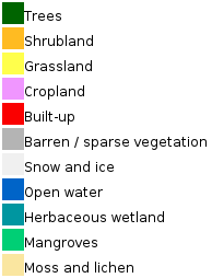
Legend ESA World Cover LandUse Map, 10m.px from 2020. See Map Layer ESA Land Cover (AOI)
Most erosion-sensitive areas with a slope of 3 degrees or more are found in the Barren Land, Crop Land and Grass Land layers. The “Forest” layer is included to monitor the expansion of the “Food Forest” (Trees) and to detect erosion as a result of deforestation.
The specified land use category layers are included in the map.
GIS Details Provided in Map
| 1. High-resolution images from Google Earth to inspect the soil conditions on the date of the image. (Check the date in GE>View>Historical images). 2. Topography Licungo sub-basin (FoodForest) - 30m/px DEM raster. Minimum elevation 200m and maximum 2200 metres above sea level. Slide the transparency in ‘Layers’ and select the Map>Terrain box to combine the DEM with 20m contour lines for better visualisation. (Example) 3. Slopes greater than 3 degrees are assumed to be more sensitive to water-related soil erosion. All slopes exceeding 3 degrees are coloured red (‘Slope’ layer). 4. The ESA Land Use WorldCover for 2020 is used, which contains more details on ‘barren land’. Farmland and grassland that could be affected by erosion are also included as individual layers to make it easier to search for potential erosion areas. For comparison, the ESA WorldCover 2021 algorithm for 2021 is included as a layer. 5. The forest layer, is expected not to erode. However in case of deforestation It is possible to track the impact on erosion in forested areas and observe trends since 2020. 6. The complete set of land use layers can be assessed within the ESA Land Cover Layers. |
Procedure for Verifying Known Eroded Areas:
- In "Google Earth (GE)" zoom to known eroded area and check and memorize nearby place label (do not forget to check box in GE "borders and labels")
- Fill name in "Search" window "Google Earth Engine" Map on Maji Yetu webpage.
- Click and drag map to required known location (hand symbol upper left), check land use category of eroded by switching between land use layers in the upper right
- Select areas of interests (AOI) and save in GE as polygon or rectangular kml files. Share the AOI-s with maji yetu to select appropriate areas for monitoring of erosion sensitive area.
Examples of Erosion and Performance Land Use Categories
Visit the Google Earth Engine map with examples of erosion and limitations of applying land use categories. On this map, the visual and calculated monitoring routine will be carried out.